When it comes to positioning, Global Navigation Satellite Systems (GNSS) stays at the front of navigation technology. GNSS covers five constellations: GPS (US), QZSS (Japan), BeiDou (China), Galileo (EU), and GLONASS (Russia). Traditional GNSS receivers measure the time taken for a signal to travel from a satellite to the receiver, and uses this time delay to calculate the receiver’s location.
However, relying solely on these traditional GNSS receivers results in a relatively low positional accuracy, typically within a range of 2 to 4 meters. This imprecision arises from various sources of error, including atmospheric interference, satellite clock errors, and receiver noise.

What Is RTK?
RTK, which stands for Real-Time Kinematic, is a sophisticated technique used in satellite navigation systems, such as GNSS, to enhance the accuracy of position data obtained from satellite-based positioning systems.By integrating RTK, positioning systems can provide centimeter-level accuracy in real-time measurements. This high level of accuracy is particularly beneficial in fields such as agriculture, surveying, and construction, where precise measurements are critical for project success.
How RTK Works?
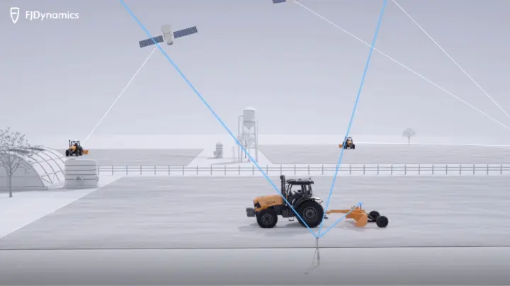
RTK measures the relative positions using two GNSS antennas in real-time with better accuracy. The errors found in GNSS results are determined and corrected using RTK technology. Generally, an RTK setup consists of two receivers. One of them, called the base station or GNSS receiver, is stationary, while the second receiver, called rover, moves freely.- Base station: A fixed receiver at a known location receives satellite signals and processes the data to generate precise position information.
- Rover: A mobile receiver for requiring position data, which also tracks the same satellite signals.
- Data transmission: The base station transmits correction data to the rover, either via radio or a cellular connection.
- Real-time corrections: The rover receives and applies these corrections to its own observations of satellite signals, effectively removing errors.
- Centimeter-level accuracy: By utilizing these corrections, RTK enables the rover to determine its position with centimeter-level accuracy, a significant improvement over the meter-level accuracy achievable with standard GNSS.
Applications
As RTK can provide positioning data that is accurate to within centimeters, it is ideal for a wide range of applications and activities that require higher accuracy, including:- Surveying and mapping: Create precise maps and survey land for construction and infrastructure projects.
- Construction and engineering: Guide heavy machinery, monitor construction progress, and ensure accurate placement of structures.
- Precision agriculture: Optimize farming practices by providing precise location data for planting, fertilizing, and harvesting.
- Geodesy and earth sciences: Monitor land deformation, study tectonic plate movement, and conduct geophysical research.
- Autonomous vehicles: Enable precise navigation and control for self-driving cars, drones, and robots.
Benefits
There are numerous benefits of using RTK technology for positioning, making it a highly sought-after solution in various industries. Some of the key benefits of RTK positioning include:- High accuracy: Deliver significantly improved positioning accuracy compared to standard GNSS, reaching centimeter-level precision.
- Real-time positioning: Provide position data in real-time, making it suitable for dynamic applications where immediate location information is essential.
- Improved reliability: Be less susceptible to interference and multipath effects, which can compromise the accuracy of other positioning methods.
- Increased efficiency: Allow for faster data collection and processing. This is particularly beneficial for applications such as surveying, where time is a critical factor.
- Reduced costs: Reduce the costs associated with positioning by minimizing the need for repeated measurements and reducing the time required for data collection.
Limitations
While RTK technology is a powerful tool for precise positioning and navigation, it does have limitations and requirements that must be considered when planning a project.Firstly, RTK technology is not accessible in marine areas, which includes locations such as oceans, seas, and large bodies of water where traditional terrestrial communication signals may be weakened or entirely absent.
RTK technology also faces challenges in areas characterized by significant obstructions, including natural features such as trees and hills, as well as man-made structures like buildings and bridges. Such obstacles can interfere with the signal transmission from satellites to the RTK equipment, leading to inaccuracies in positioning.
Furthermore, projects that involve activities that disrupt communication can also prevent the effective use of RTK technology. This may include construction projects, areas with heavy machinery, or any undertaking that alters the physical landscape or environment in a way that hampers signal integrity.
Other limitation is that RTK requires a precisely surveyed base station with known coordinates. This station should be located at a point with unobstructed line-of-sight to the satellites and the rover.