


Colorization

Algorithms

Point Cloud

Adaptation

Scanning

SMALLER SIZE, LARGER CAPABILITY
The FJD Trion S2 LIDAR Scanner boasts advanced VIO and SLAM algorithms for generating high-quality and reliable point clouds. Supporting over 8000 coordinate systems, the S2 eliminates the need for time-consuming manual coordinate conversions. By integrating with FJD Trion Scan and Model software and utilizing practical accessories like stabilizing vest, drone mount, car mount, and robot dog mount, the S2 enhances data capturing and processing efficiency for outdoor surveying projects.
Ключевые преимущества
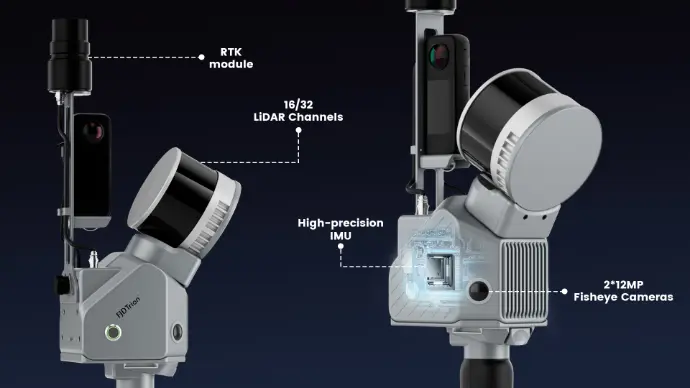
Multi-Module Integration
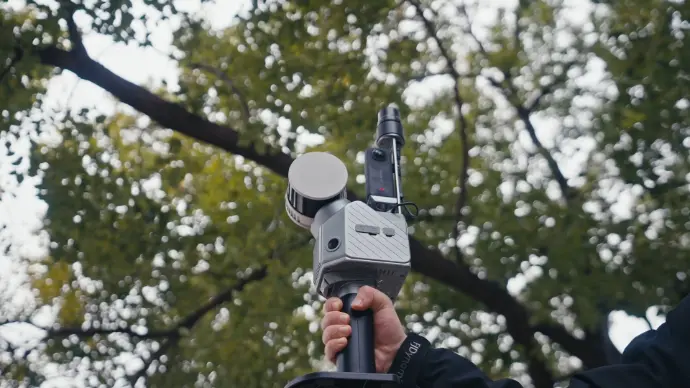
Integrate camera, IMU, and RTK modules into a compact form of 2kg in weight, allowing you to carry it around for various surveying projects.
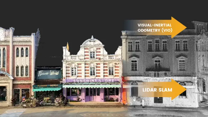
Multi-SLAM Algorithms for Accurate Output
Embed two 12MP cameras to generate high-resolution images with advanced Visual-Inertial Odometry (VIO) and SLAM algorithms, delivering accurate results even in complex environments with fewer feature points.
Georeferenced Point Cloud
With an integrated RTK module, directly get georeferenced point clouds on the go. RTK & PPK support ensure accurate data collection in dense tree canopies and other signal-challenging areas. Plus, with over 8000 coordinate systems, no fear of tedious coordinate conversions anymore!
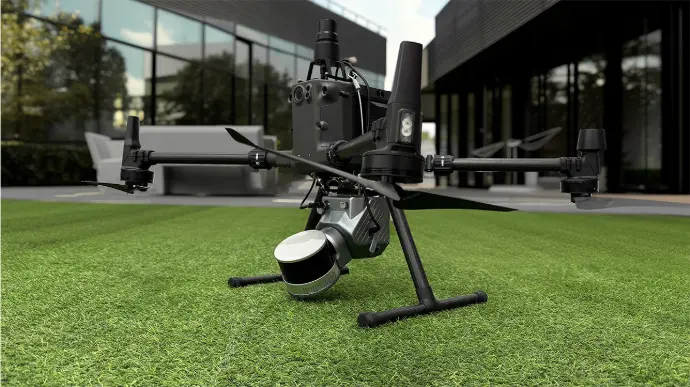
Effortless Scanning & Carrying
Capture point clouds in all directions even in hard-to-reach areas with practical accessories, including stabilizing vest, extension pole,
drone, robot dog, and rolling suitcase. You can just go and scan anytime, anywhere.
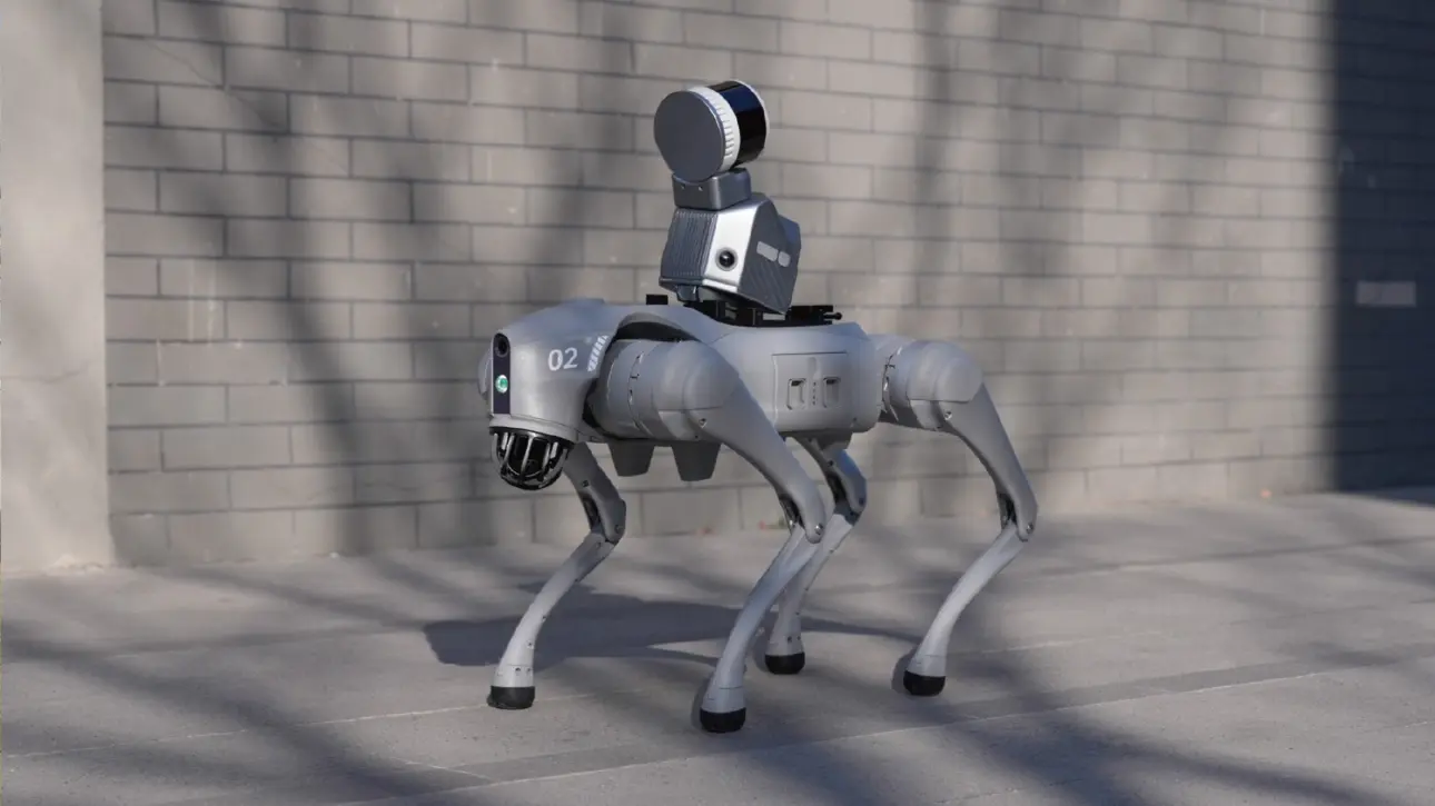


Robot Dog
Drone Mounting
Stabilizing Vest
Падаўжальнік FJD Trion
Rolling Suitcase
Safety is a priority. The robot dog integration enhances automatic navigation and inspection in challenging areas like construction sites, disaster zones, and underground facilities, improving safety and efficiency by minimizing human intervention.

Комплексное решение для облака точек
FJD Trion Scan
Real-time scanning process control APP
Enhance your scanning experience with the FJD Trion Scan APP. Scan offers real-time monitoring to guide your scanning progress, ensuring complete coverage without rework in the future.
![]()
![]()
FJD Trion Model
Программное обеспечение для обработки облаков точек
FJD Trion Model is a PC and tablet based point cloud processing solution that enables denoising, colorization, and classification. Industry-specific modules empower quick and seamless results for like floor plan and 3D model generation for construction, section analysis for tunnels, and trunk and canopy analysis for forestry.
Бесплатная пробная версия
скачать
Бесплатная пробная версия
скачать
Сценарии применения

Управление и оценка недвижимости
Оцените структурную целостность, спланируйте пространство и определите районы, нуждающиеся в ремонте или обновлении. Уменьшите неопределенность в инвестиционных решениях с помощью информации из богатого набора пространственных данных.

Общественная безопасность
Используйте данные облака точек для повышения готовности к стихийным бедствиям и планов восстановления. Быстро записывайте улики и места преступлений или происшествий для немедленной и точной судебно-медицинской экспертизы.

Архитектура, Проектирование и Строительство
Принимайте более обоснованные решения по своим проектам: от чертежей до контроля качества с помощью обследований зданий, сканирования в CAD и BIM, исполнительной документации, планов этажей и объемов складских запасов.

Topographical Survey
Accurately map and analyze terrain features with high-resolution point cloud data. Streamline land development projects, environmental studies, and infrastructure planning by capturing detailed elevation models and surface characteristics.

Mining
Improve safety and efficiency in mining operations.
Use point cloud data to assess mining environments, and improve underground mapping accuracy. Enhance operational efficiency by providing real-time insights into tunnel conditions, mineral deposits, and structural integrity.

Forestry and Vegetation Analysis
Manage and monitor tree inventory with a quick walk in the forest. Measure crowns, analyze breast diameter and tree height using precise point cloud data.
(*Accuracy measured in experimental environment)